If you’re buying property, building a fence, or making changes to your land in Illinois, you’ve probably heard the term “boundary survey.” It sounds simple enough—but is it always enough? And what about those more complex ALTA surveys people talk about?
Let’s clear things up and help you figure out when a boundary survey gets the job done, and when you might need to go a step further.
📏 What Is a Boundary Survey?
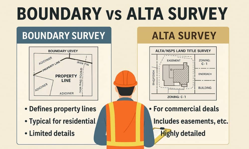
A boundary survey is the most common type of land survey used in Illinois. It shows the exact lines of your property based on legal descriptions and physical measurements. Surveyors mark the corners and often place visible markers so you know exactly where your land starts and ends.
People in Illinois typically get a boundary survey when:
- Installing fences, driveways, or landscaping
- Buying or selling a home
- Resolving simple disputes with neighbors
- Checking setbacks for zoning compliance
It’s quick, relatively affordable, and gets you clear property lines without diving into legal or title complexities.
🧾 What’s Not Included in a Boundary Survey?
Here’s where it gets tricky. A boundary survey doesn’t show things like:
- Easements (like utility or drainage access)
- Encroachments from neighboring structures
- Zoning classifications or flood zones
- Any title-related data required for legal transactions
In many parts of Illinois—especially in older suburbs or city neighborhoods like Oak Park, Evanston, or parts of Chicago—there are often hidden easements, overlapping plats, or outdated property records that a basic boundary survey won’t catch.
🏢 What Is an ALTA Survey—and How’s It Different?
An ALTA/NSPS Land Title Survey is a much more detailed survey, usually required for commercial properties or complex transactions. It’s based on national standards from the American Land Title Association and includes everything a boundary survey does—plus legal, zoning, and title elements.
You’ll typically need one in Illinois if:
- A lender or title company requests it
- You’re buying or refinancing commercial or industrial property
- You’re preparing a site for redevelopment or new construction
- There are known legal issues or overlapping parcels
For example, in downtown Springfield or Chicago’s West Loop, ALTA surveys are often required due to tight lot lines, zoning overlays, and multi-use buildings.
🔍 When Is a Boundary Survey Enough in Illinois?
Here’s the good news: in many cases, a boundary survey is all you need—especially if:
- The property is residential
- You’re not involving a bank or title insurance
- There are no known encroachments or easements
- The local zoning board or permit office doesn’t require more
In cities like Naperville, Peoria, or Rockford, local builders often rely on boundary surveys for home additions, fence placement, or permit applications—assuming the property history is clean and no title issues exist.
⚠️ When It’s Not Enough
A boundary survey might not be enough if:
- You’re dealing with older properties where land records are messy
- The site has shared access, like a private drive or alley
- There’s potential for legal disputes
- You’re building multi-family or commercial structures
Many Illinois counties—like Cook, DuPage, and Lake—have specific requirements for surveys submitted for permitting or redevelopment. In those cases, skipping the ALTA survey could delay your plans or lead to legal trouble.
💬 Final Thought: Ask Before You Survey
A boundary survey can save you time and money—but only if it covers what you need. Before scheduling any survey in Illinois, ask:
- What’s the property going to be used for?
- Is it residential or commercial?
- Will a lender, title company, or city planner need to review it?
When in doubt, speak to a licensed Illinois surveyor or your real estate attorney. They’ll help you decide whether a boundary survey is truly enough—or if an ALTA survey will save you bigger problems down the road.